

Regional risk assessment + Action suggestions SONAE Research
Research various disaster risk information in cooperation with external systems and information networks.
It is an original service that predicts damage situations and detailed damage, and offers concrete solutions
for damage reduction from investigation to proposal and production.
In addition to providing business continuity support from a disaster prevention perspective, it is also effective as a
sales tool for overall land use and as a service for customers. SONAE converts various risks into value.
Organizing basic information using disaster prevention technology
Centralized display of disaster risk
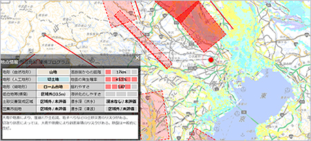
of damage estimates
A wide range of disaster risk information such as earthquakes, floods, landslides, and wind damages (probability of earthquake occurrence, ease of shaking, ease of liquefaction, assumed inundation depth, etc.) is shown in a unified format. It is possible to estimate the damage by setting the building information. It is a web service that presents appropriate prior action suggestions based on risk assessment and damage estimation.
immediately after the earthquake
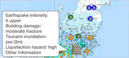
Be prepared for a major earthquake that will "come one day" in every region. The distribution of shaking and damage to buildings were estimated by simulation technology based on academic research and engineering conducted by Kozo Keikaku Engineering Inc. (Structural Planning Research Institute). In addition to the estimation, we can provide the latest information immediately after a disaster including road traffic conditon, actual damage information such as the occurrence of a fire, spread of a fire, and human damage.
sensor information and image data.
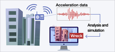
Using information obtained from sensors and building information (type of structure, age of building, etc.), the damage situation of the building is estimated immediately after the earthquake.
Cracks are also detected from image data of major structural components (beams and walls). You can instantly determine the damage situation of the building. It can be used to construct a real-time evacuation information system immediately after an earthquake.
damage to facilities
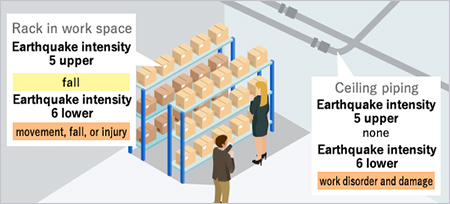
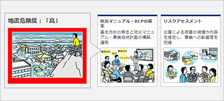
Even if the building is safe right after the earthquake, the business will be stopped if there is damage to facilities and important objects. However, if you can't predict the degree and scale of damage, you can't take measures.
As a preparedness for BCP, this consulting service supports the policy of countermeasures by estimating damage for business continuity and verifying the effects of earthquake countermeasures.
We can visualize the vague image of "disaster" and use it to formulate in-house standards for measures for internal facilities.
disaster response actions.
A preparedness for loss on business
opportunities
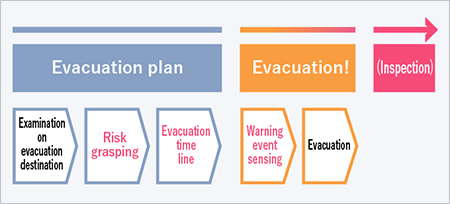
As a preparedness for operating losses (loss on sales, service cutbacks and outages) such as damage to products due to the disaster, we provide a "evacuation timeline" from the occurrence of the disaster to the occurrence of the damage. It can be used as a planning tool for the planned evacuation of products. There is also an option to sense disaster warning information and send an evacuation alert to administrators in cooperation with the Real-time Flood Forecasting System (RiverCast) and the L-Alert System (Disaster Information Sharing System) promoted by Ministry of Internal Affairs and Communications.
Predict disasters before they occur
and advise on actions to be taken in
the event of a disaster.
+ action suggestion service
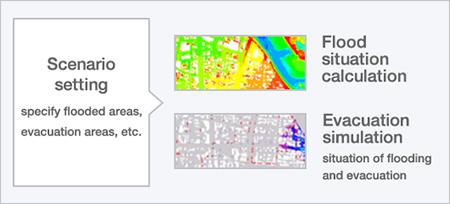
In addition to flood hazard map information, which has been required to be explained during real estate transactions since 2020, we provide detailed disaster prediction information by considering small and medium-sized rivers through flood simulation using topographical information.
It is an original service that can provide the appropriate action suggestion in case of disaster.
can be understood from the address.
countermeasures
Disaster risk is assessed in three stages based on address. It is a service to present guidelines for various measures from the viewpoint of prevention and reduction of damage and emergency response regarding pre- and post-disaster response.
Depending on your risk assessment and issue, we can offer you a range of solutions. (Research/consulting, hardware measures, systems/services, equipment/devices/goods, insurance finance, etc.)
information and features
-
 Damage estimation
based
on potential
vulnerabilities -
 Conducting damage
estimation
based
on actual risks -
 Linking with external
systems
by providing APIs -
 Services provied
by
consulting on
consignment