

Supporting corporate sustainability from the perspective of disaster prevention SONAE Consulting
As the concept that the three perspectives of ESG (Environment, Social and Governance) are necessary is
spreading worldwide, our knowledge on disaster prevention can present various risk assessments
and specific improvement measures required not only in the BCP domain but also in the ESG context.
Things disaster prevention can do for ESG
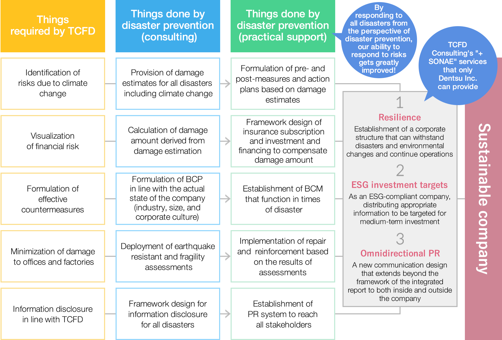
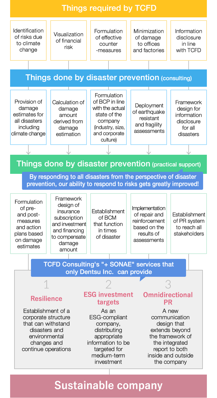
TCFD is often discussed in the context of ESG investment. In the creation of scenarios, which is one of the priority items of TCFD, our services, which have expertise in the field of disaster prevention, identify all disaster risks and present improvement plans, thereby providing solutions to improve relationships with supply chains, employees and other stakeholders, and to ensure specific sustainability.
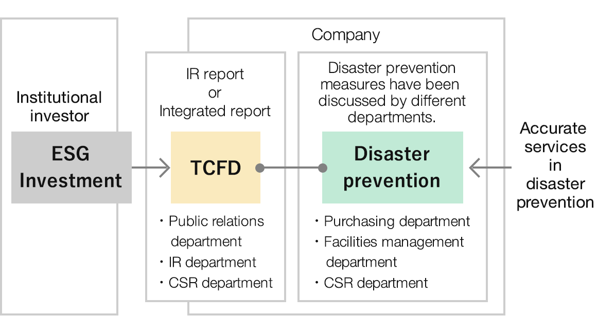
As opportunities for ESG investment increase, companies are required to disclose more open and specific information. The public relations, IR, and CSR sections that previously supported TCFD need now to collaborate with the section in charge of disaster prevention (purchasing, facility management, etc.) to approach TCFD on a company-wide basis. + SONAE services connect TCFD with disaster prevention of the company.
Perspective of disaster prevention and SDGs
Sustainable Development Goals (SDGs) are the goals set by the 193 member states of the United Nations for 15 years from 2016 to 2030.
Out of 17 established issues, 9 items are related to disaster prevention. It is possible to combine the environmental and social issues addressed by companies as a realistic piece of business, by considering the situation in which risks are maximized as a "time of disaster" and organizing the company's efforts for SDGs in the context of disaster prevention.

1.5Protecting the poor and vulnerable from climate disasters

2.1Helping the poor and vulnerable obtain safe and nutritious food
3.6Halving the number of casualties caused by traffic accidents 3dEarly warning of health hazards

4aProviding a safe learning environment by improving schools
9.1Developing quality, sustainable and resilient infrastructure
11.2Expansion of public transport, safety of transport 11.5Significant reduction of fatalities and victims of disasters, less economic losses relative to GDP 11bDissemination of comprehensive disaster prevention plans and management of disaster risks

13.1Disaster preparedness in all countries 13.3Early warning education and awareness 13bClimate change response in least developed and small island countries
14.2Restoration of marine and coastal ecosystems

15.3Recovering land and soil damaged by desertification, drought and flooding
Organizing basic information using disaster prevention technology
Centralized display of disaster risk
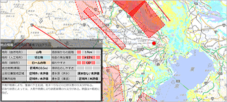
of damage estimates
A wide range of disaster risk information such as earthquakes, floods, landslides, and wind damages (probability of earthquake occurrence, ease of shaking, ease of liquefaction, assumed inundation depth, etc.) is shown in a unified format. It is possible to estimate the damage by setting the building information. It is a web service that presents appropriate prior action suggestions based on risk assessment and damage estimation.
immediately after the earthquake
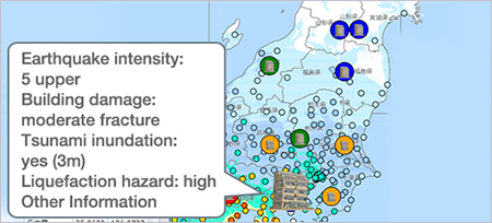
Be prepared for a major earthquake that will "come one day" in every region. The distribution of shaking and damage to buildings were estimated by simulation technology based on academic research and engineering conducted by Kozo Keikaku Engineering Inc. (Structural Planning Research Institute). In addition to the estimation, we can provide the latest information immediately after a disaster including road traffic conditon, actual damage information such as the occurrence of a fire, spread of a fire, and human damage.
sensor information and image data.
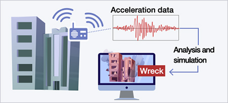
Using information obtained from sensors and building information (type of structure, age of building, etc.), the damage situation of the building is estimated immediately after the earthquake.
Cracks are also detected from image data of major structural components (beams and walls). You can instantly determine the damage situation of the building. It can be used to construct a real-time evacuation information system immediately after an earthquake.
damage to facilities
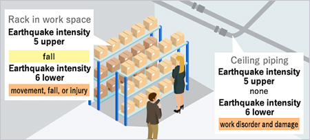
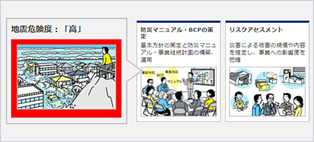
Even if the building is safe right after the earthquake, the business will be stopped if there is damage to facilities and important objects. However, if you can't predict the degree and scale of damage, you can't take measures.
As a preparedness for BCP, this consulting service supports the policy of countermeasures by estimating damage for business continuity and verifying the effects of earthquake countermeasures.
We can visualize the vague image of "disaster" and use it to formulate in-house standards for measures for internal facilities.
disaster response actions.
A preparedness for loss on business
opportunities
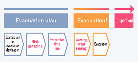
As a preparedness for operating losses (loss on sales, service cutbacks and outages) such as damage to products due to the disaster, we provide a "evacuation timeline" from the occurrence of the disaster to the occurrence of the damage. It can be used as a planning tool for the planned evacuation of products. There is also an option to sense disaster warning information and send an evacuation alert to administrators in cooperation with the Real-time Flood Forecasting System (RiverCast) and the L-Alert System (Disaster Information Sharing System) promoted by Ministry of Internal Affairs and Communications.
Predict disasters before they occur
and advise on actions to be taken in
the event of a disaster.
+ action suggestion service
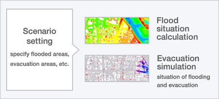
In addition to flood hazard map information, which has been required to be explained during real estate transactions since 2020, we provide detailed disaster prediction information by considering small and medium-sized rivers through flood simulation using topographical information.
It is an original service that can provide the appropriate action suggestion in case of disaster.
can be understood from the address.
countermeasures
Disaster risk is assessed in three stages based on address. It is a service to present guidelines for various measures from the viewpoint of prevention and reduction of damage and emergency response regarding pre- and post-disaster response.
Depending on your risk assessment and issue, we can offer you a range of solutions. (Research/consulting, hardware measures, systems/services, equipment/devices/goods, insurance finance, etc.)